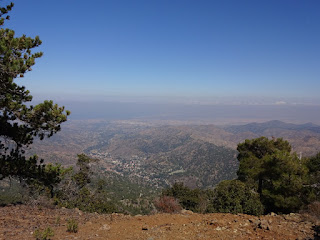
A long climb downhill on some interesting paths, then a climb up to an area with vineyards as well as pines.
This morning I had planned to visit the Forestry Visitor Centre in Troodos before heading off. Not well signposted I found it a little to the west of the village centre. Unfortunately, as there was no electricity I was not allowed to see the exhibits. Leaving Troodos on the tarmac road I briefly peered through the gates of the Military cemetery, which contained graves of British soldiers from the 19th century. A couple of faded poppies were attached to the cemetery gate, I was glad someone remembered them. There was also an abandoned asbestos quarry beside the road, if I understood some earlier sign correctly. No asbestos fibres were visible among the rocks by the road. The E4 left the road through pine trees and Golden Oak on rock strewn ground. After an initial vehicle track, it followed a rocky footpath which took me down to the Platania forestry buildings and picnic site. The footpath criss-crossed scree slopes with some slippery gravel in places. There was a lot of exposed rock and scree, whether man made or not I could not tell.
After Platania there was the inevitable climb up the other side of the valley by another mouflon enclosure, the wild sheep were all hiding somewhere out of sight when I passed. Reaching the top of the ridge I crossed to the other side into the valley beyond where the pine trees had been replaced by terraces of vines, tomatoes, apples and the like. After a nature trail back among the trees (including strawberry trees with bright red berries) I turned off the E4 and followed another nature trail, complete with steps, down the steep slope to Spilia. I was welcomed to Flora's house with coffee, a sweet and fruit. Later Soto fed me more than I could eat down in his coffee shop in the village. As I ate, villagers wandered in and out, one over 90 years old, it seemed to be a mail collection point and general point for assistance and information exchange.
18 kilometres walked with a 410 metre total ascent. A gps file of my walk can be downloaded from wikiloc.com or ViewRanger under short code johnpon0045.
 |
| E4 footpath across some slippery scree. |
 |
| A change from pine forest to vineyards on terraces. |

No comments:
Post a Comment